Over the past two years, Nelson City Council’s Plan Change 29 has been the city’s most significant planning process, affecting many property owners.
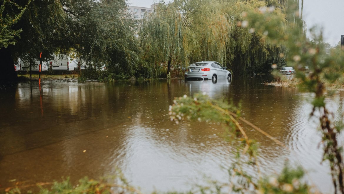
Proposed in 2023, the overhaul focuses on housing density and managing natural hazards. PC29 introduced new hazard overlays for slope instability, flooding, fault lines, and liquefaction. When the consultation maps became public, the effects were immediate. Insurers grew cautious, lenders asked more questions, and some property sales fell through. One homeowner described her property, which had never previously been an issue for insurance, as almost uninsurable due to its position on the maps.
That process has now concluded. Following hearings in August and September 2024, an independent panel issued recommendations in May 2025. Nelson City Council accepted these recommendations in full on June 5, 2025, with parts of PC29 coming into legal effect on October 21, 2025. Here’s what that means in practice.
What is now in effect: flood, fault, and liquefaction
Three hazard overlay categories are now active under PC29:
Flood hazard
Three new overlays and three amended overlays now are the latest flood modelling for Nelson. If your property is in one of these zones, specific rules govern what can be built and how. The earlier flood provisions in the operative NRMP have been updated and, in some cases, expanded.
Fault Awareness Overlay
This overlay finds land that may be subject to deformation due to fault ruptures. It refers to a “poorly defined” fault line, which is an important note. The overlay is meant to encourage caution and proper assessment, not to consider a property uninsurable or undevelopable.
Liquefaction Hazard Overlay
This marks areas where ground damage from liquefaction could occur during a strong earthquake. If your property falls within this overlay, any development needing consent will be evaluated based on the new rules.
In practice, if you are buying, selling, or planning development on land within these zones, the current provisions now apply. Resource consent requirements could differ from those before October 2025. It is crucial to get updated advice, rather than relying on pre-PC29 information.
The slope mapping outcome and its implications
One of the key results of the PC29 process is what did not move forward: the proposed Slope Instability Hazard overlay.
The hearing panel received extensive submissions on this topic, including input from geotechnical and structural engineers. Many submitters documented the real-world effects of the notified maps on property sales and access to insurance. The panel took these effects seriously. They viewed them as important for assessing the accuracy and suitability of the proposed overlays.
The conclusion was clear: the proposed slope risk overlays are not accurate or reliable enough to be used as regulatory tools at this time. Expert evidence showed that the overlays incorrectly label some safe sites as hazardous and miss other areas that truly have risk. This dual failure reduces their value as a regulatory instrument and means they do not meet the efficiency standards under Section 32 of the Resource Management Act.
The panel recognized that slope instability is a genuine and serious hazard that needs management. The concern wasn’t whether the risk exists, but if these specific overlays were appropriate. The panel believed that the current rules in the operative NRMP provide sufficient regulation, especially for larger earthworks and development activities, and that the proposed overlays were not ready to complement them.
Better mapping may be developed in the future, and the panel left that possibility open. For now, though, Nelson continues to operate under its existing slope hazard framework instead of the expanded and contested provisions proposed under PC29.
Every LIM now requires a dedicated natural hazards section
Previously, hazard information could appear in various parts of a LIM in inconsistent formats. Now, there is a standard section in plain language with maps, covering all known and potential hazards, including climate change impacts.

Regional councils must now provide hazard information
Under the amended LGOIMA, regional councils must share the hazard data, models, and reports they have, along with plain language summaries, with territorial authorities. This closes a gap where important regional hazard data may not have been included in a property’s LIM.
The information is now more thorough
LIMs must cover not just confirmed hazards but also potential hazards; a broader and more forward-looking range. Flood susceptibility, slope conditions, liquefaction risk, coastal inundation, and the fault awareness layer may all now be found in a standard, clear format.
What this means for buyers: a LIM obtained now looks quite different from one bought 18 months ago. There is more information, it is easier to understand, and it is more likely to highlight risks that were previously buried in technical language. This is a positive change, but it can also make properties seem riskier, even when the actual risk has not changed.
What this means for sellers: hazard information is now more visible and understandable to your buyer’s solicitor. It is better to be proactive by providing a current LIM, any relevant site-specific reports, and clear context, than leaving buyers to interpret it without help.
Why this moment matters for buyers and sellers
Nelson’s property market is going through a real transition. The hazard overlay framework has changed significantly. The LIM documents that buyers rely on have also changed a lot. These two shifts happening at the same time create both clarity and complexity.
The clarity: we now know the current planning rules. The uncertainty of the PC29 process, which affected the market for nearly two years, is mostly resolved. For most properties in Nelson, the rules are clearer today than they were in 2023.
The complexity: more information, presented more consistently, leads to more questions. Buyers who receive a LIM with a significant natural hazards section and straightforward descriptions of flood, liquefaction, and fault designations will form opinions. Some will ask tougher questions than buyers did 18 months ago. How those questions get answered and what supporting information is available will be important.
For sellers, preparation is the right response. For buyers, it’s essential to grasp what a designation means, and what it doesn’t mean, before reaching conclusions.
What is recommended
- Obtain a current LIM. Any LIM issued before October 2025 reflects a different regulatory environment. Pay attention to the natural hazards section, both what is included and how it is described.
- Check the operative overlays. Nelson City Council’s natural hazards GIS viewer shows the operative PC29 overlays (flood, fault, liquefaction) alongside the existing NRMP slope provisions.If your property is in any overlay, understand what rules now apply.
- If you were among the 1,100 wrongly labelled for slope risk: confirm that the corrected mapping appears in your current LIM and in the Council’s records.
- If you are selling collaborate with your agent early. A current LIM, any site-specific geotechnical or engineering reports, and a clear factual account of your property’s position within the overlays will help buyers engage confidently instead of cautiously.
- If you are buying do not see a hazard designation as a final judgment. The operative overlays find areas needing careful assessment, not properties that cannot be developed, insured, or financed.
- If you are planning development: the rules for your property may have changed since October 2025. Get current planning advice before assuming what was allowed before PC29 is still allowed now.
If you want to discuss what any of this means for your property specifically, we are happy to talk it over.
FAQs
Does the rejection of the slope overlay mean there are no slope risks in Nelson?
No. The existing NRMP slope overlays are still in effect. What was rejected was the proposed new overlay under PC29, which was broader and, in over 1,100 cases, based on a software error. The current framework continues.
My property is in a flood overlay. What does that mean for me?
It depends on which overlay and what you plan to do. For selling an existing home, the overlay creates a disclosure and buyer education issue rather than a practical barrier. For anyone looking to build or significantly renovate, getting current planning advice is crucial.
Will the new LIM format affect my property's value?
Potentially, but only slightly. More noticeable hazard information may make some buyers more cautious. However, properties with solid supporting documentation, including site-specific reports, clear LIMs, and council correspondence, are in a better position than those that leave buyers to interpret raw hazard designations without context.
Do I need to show hazard information when selling?
You should always be upfront with valuable information. The litmus test is “is this information pertinent to a purchaser’s decision to buy?”
Your agent and solicitor can best recommend you on your specific disclosure obligations
Is the PC29 process fully settled?
Mostly, but not completely. An Environment Court appeal has been filed involving 13 parties about the residential intensification provisions, not the hazard overlays. The hazard overlay decisions are in effect and are not included in the appeal.
Are the new LIM regulations specific to Nelson?
No, they apply nationally. But for Nelson, they coincide with the PC29 operative changes, meaning both the content and the way hazard information is presented have changed at the same time. That combination is unique to this moment, June 2026, in Nelson’s market.
Disclaimer
This article is for general information only and reflects publicly available information at the time of writing. It is not legal, planning, or engineering advice, and should not replace a LIM, property file review, or independent professional assessment. Planning provisions, hazard information, and council positions can change. If you are buying, selling, developing, arranging insurance, or seeking finance, get proper advice from your solicitor, planner, insurer, lender, and/or a qualified geotechnical professional.
If you are considering selling this year, we would be happy to talk. Not to secure the listing, but to help you evaluate whether this is the right time for you.